Discover Iran: Dezful, the ‘bridge city’ where rivers, heritage, and history flow together
By Ivan Kesic
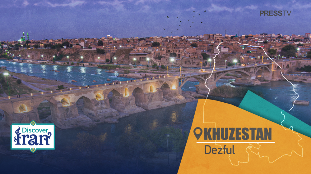
- A city of ancient bridges, gushing rivers, and traditional architecture, Dezful in the north of Khuzestan blends natural beauty with thousands of years of heritage
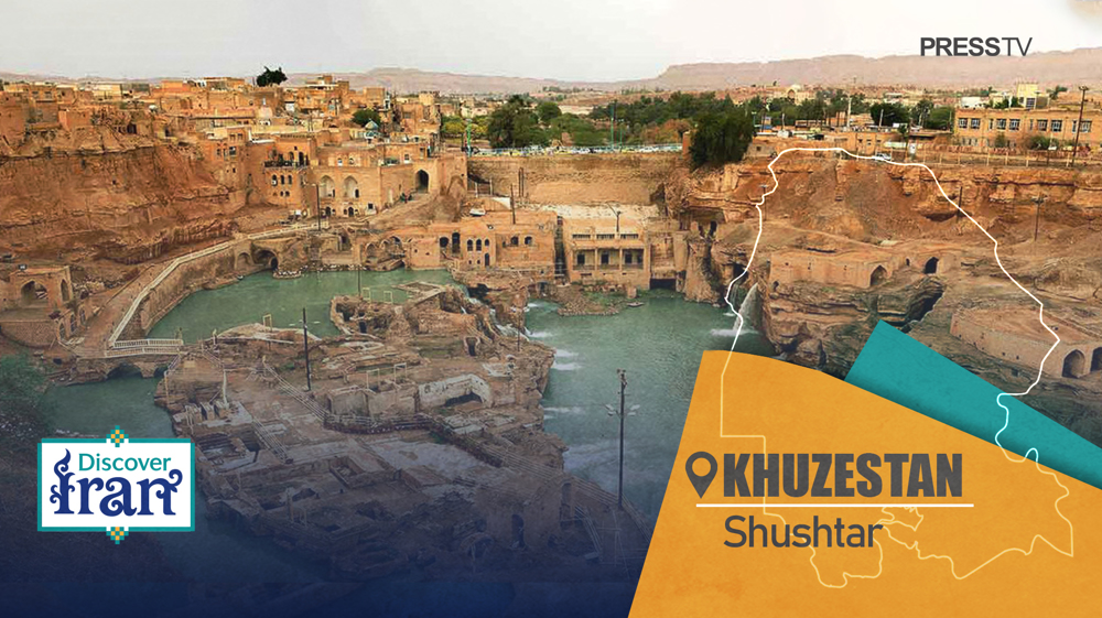
- After Shushtar, Dezful represents the second most important hydraulic complex in Iran, featuring a diverse array of ancient water management structures
- The city’s name, meaning “Bridge of Dez,” reflects its rich legacy, with architecture from the Safavid and Qajar eras and many historic buildings registered as cultural heritage.
Dezful is a historic city in southwestern Iran’s Khuzestan Province, located approximately 150 kilometers north of the provincial capital, Ahvaz, and about 650 kilometers south of Tehran.
Nestled on a water-rich plain just a few kilometers from the foothills of the Zagros Mountains, Dezful sits at an elevation of 143 meters on the high left bank of the Dez River, the second-largest river in Iran by water volume, after the Karun River.
This fertile plain, stretching 130 kilometers long and 50 kilometers wide, is nourished by the Karun, Dez, and Karkheh rivers and is home to many historically significant cities and archaeological sites.
Unlike typical ancient Iranian cities built inland at the foot of mountains to utilize underground qanat irrigation, Dezful and its neighboring urban centers follow the Mesopotamian model, developing along riverbanks.
Historically, the broader area around modern-day Dezful dates back over 5,000 years, with traces of settlements from the Elamite period. However, the city’s urban origins trace to the Sassanid era (224–651 CE).
The name Dezful derives from "Dezh-pol," meaning “fortress bridge” in Persian, reflecting its foundation around a Sassanid-era bridge. Historically, the Dez River was known as the Gondeshapur River, later renamed after the city.
While the bridge’s construction is sometimes attributed to the 3rd-century ruler Shapur I and his Roman captives, modern historians believe it was built during the 4th century under Shapur II’s reign.
This sturdy arch bridge-dam, approximately 350 meters long, is among the world’s oldest surviving bridges and holds the distinction of the longest continuous use, spanning roughly 1,700 years up to the 21st century.

The stone foundation of the bridge remains visible today, while its upper section – with distinctive pointed arches – has been repeatedly reconstructed in brick throughout the Buyid, Seljuk, Safavid, and Qajar periods, as well as in modern times.
In the 20th century, during the early Pahlavi era, the collapsed central portion was replaced by three concrete arches. The bridge continued to serve city traffic until 2010, when motor vehicles were banned from crossing to preserve the historic structure.
Situated at the intersection of an ancient trade route and a water-rich river, the site’s fertile soil and the protection offered by the fortress made it an attractive hub for trade and settlement as early as the Sassanid period.
The city’s most significant historic economic activity was crop milling powered by hydraulic energy. Sugarcane, cultivated for over a thousand years, remains an important economic crop today.
Dezful is a key agricultural center, renowned for its citrus fruits, especially oranges, as well as for rose and tuberose flowers, wheat, barley, rice, clover, alfalfa, sesame, maize, grass peas, and livestock such as buffalo, which provide high-quality dairy products.
Along the Dez River, there were once about 50 watermills, with substantial remains of approximately 15 still visible just a few meters downstream from the Old Bridge. These boat-shaped mills were built directly on the river’s surface.
The historic center of Dezful represents Iran’s second most important hydraulic complex, after Shushtar, encompassing nearly every type of ancient hydraulic structure.
The old city center was divided into around 30 quarters. Some were located on the waterfront with direct river access, while others accessed water through indirect means.
Waterfront quarters enjoyed accessibility via sloped alleys known as "bendar," constructed perpendicular to the river’s flow. These alleys provided residents with direct access to water and allowed fresh breezes to circulate through the streets.
In contrast, inhabitants of the non-waterfront quarters relied on innovative water supply methods, utilizing an underground stream fed by the river from the upper parts of the city.

These unique underground streams, known locally as "ghomesh," are a distinctive feature of Dezful – though similar to qanats, they are virtually nonexistent elsewhere in Iran.
Historically, there were more than ten ghomeshes in Dezful, and staircases were built to provide access to these vital water sources.
The central role of the Dez River in the old town is vividly captured by French archaeologist Jane Dieulafoy, who, after visiting at the end of the 19th century, wrote that “the houses seem to sit like spectators in a theater, watching the river.”
Beyond agriculture and crop milling, indigo production was another important local industry.
Indigo, extracted from a wild grass growing along the riverbanks, was processed in ponds near the river to produce a fine sky-blue pigment used traditionally for dyeing textiles and ceramics.
This industry flourished mainly during the 19th century, with about 120 factories operating in the city.
Dezful’s population has grown significantly, from around 16,000 at the end of the 19th century to over 250,000 today. Together with the neighboring city of Andimeshk, the combined urban area exceeds half a million inhabitants.
In addition to its hydraulic heritage, Dezful boasts numerous other attractions, including a thousand-year-old congregational mosque, mausoleums, shrines, hammams, and historic homes.
The old neighborhoods, characterized by Safavid and Qajar-era brickwork and interconnected alleys, have earned Dezful the nickname "the brick museum of Iran" due to its distinctive brick structures and intricate designs.
Some alleys are roofed, and many houses feature cellars, or shabestans, where residents seek relief from the summer heat.
During the imposed war in the 1980s, Dezful came under numerous attacks from West-backed Baathist regime forces in Iraq, damaging nearly 15,000 residential, religious, and cultural structures. Nevertheless, reconstruction efforts began promptly to restore the city’s heritage.
In the early 2010s, the UNESCO office director in Dezful announced that over 300 documents, totaling 10,000 pages, had been compiled to support the nomination of Dezful’s historic center for inclusion on the World Heritage List.

Discover Iran: Sistan and Baluchestan Science and Tech Park powering innovation and growth
Discover Iran: How once-isolated Makran coast is rising as Indian Ocean’s next strategic powerhouse
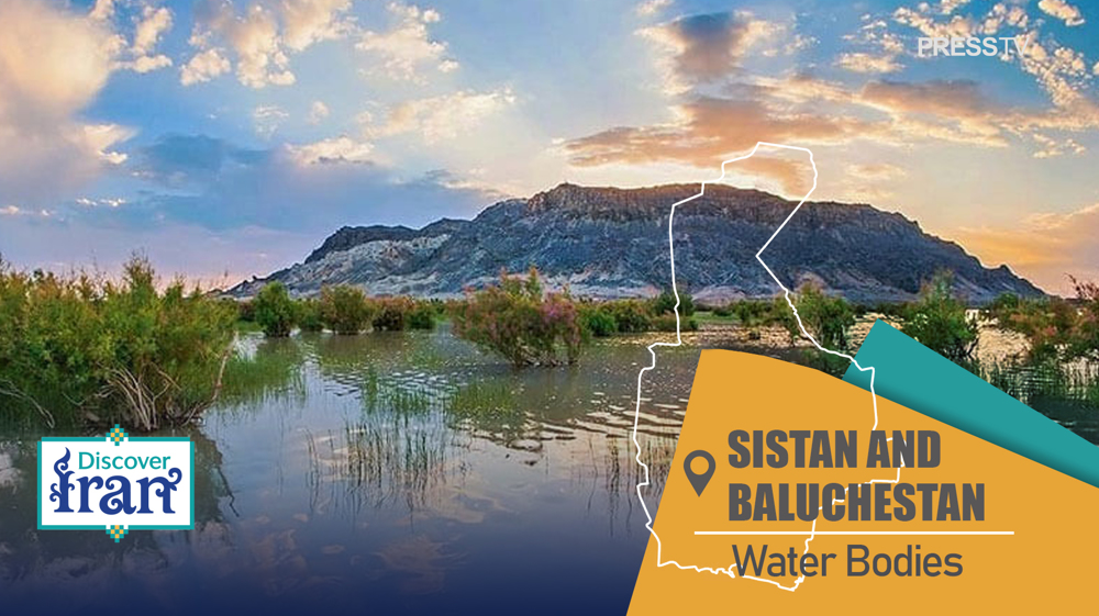
Discover Iran: The network of rivers, lakes, and wetlands of Sistan and Baluchestan


Iran's World Cup dream ends after late Austria goal denies historic knockout berth
'Decisive response': IRGC strikes eight US military installations after renewed American attacks
US CENTCOM reports renewing aggression against Iran
Details announced for funeral ceremonies as nation prepares to bid farewell to martyred Leader
Iran clinches 2026 CAFA Women's Futsal Championship
Israel keeps bombing Lebanon, prepares for long occupation
Mission unaccomplished – IV: Iran’s missile arsenal the US could neither destroy nor negotiate away
Taremi blasts FIFA after VAR heartbreak leaves Team Melli's knockout hopes hanging