Through lens of satellite imagery: How Iran's precision strikes dismantled America's Persian Gulf military network
By Yousef Ramazani
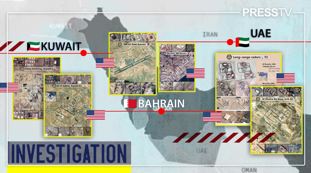
In a coordinated campaign of ballistic missile and drone strikes spanning both the opening and later phases of the US-Israeli war of aggression, Iranian forces systematically dismantled the backbone of America's military infrastructure across the Persian Gulf, reducing more than a dozen key installations to ruins and exposing the vulnerability of what had long been portrayed as an impregnable fortress.
The military bastion Washington had spent decades constructing across the Persian Gulf – a vast network of bases, air defenses, naval facilities, and logistical hubs designed to project power, contain Iran, and dominate the region – was shaken in a matter of hours.
When the joint US-Israeli aggression against Iran began on February 28, 2026, with the martyrdom of the Leader of the Islamic Revolution, top military commanders, senior officials, and hundreds of civilians, the Islamic Republic responded with “Operation True Promise 4,” a devastating and precisely coordinated campaign that systematically targeted the very architecture of American military architecture across West Asia.
Iranian ballistic missiles and kamikaze drones penetrated layers of American air defenses, striking more than a dozen military installations in Kuwait, Bahrain, Qatar, the United Arab Emirates, and Jordan.
Simultaneously, long-range missiles and drones targeted the headquarters of the US Fifth Fleet, strategic radar facilities, command centers, and other high-value military assets.
Satellite imagery and battlefield assessments indicate that Iran's military-technological capabilities reached a level few American planners had anticipated.
Precision strikes degraded or destroyed critical infrastructure, including the approximately $1.1 billion AN/FPS-132 early-warning radar, hangars housing F-35 fighter jets, command-and-control centers, ammunition and logistics hubs, and other essential nodes that sustained American military operations throughout the region.
Camp Buehring: Logistics hub brought to its knees
Camp Buehring, located in the northwestern Kuwaiti desert near the Iraqi border, is the US Army's principal ground-force staging base in Kuwait. It serves as a critical reception, staging, onward movement, and integration (RSOI) hub for personnel and equipment entering the US Central Command (CENTCOM) theater.
Satellite imagery reveals a sprawling military complex comprising vehicle parks, warehouses, barracks, motor pools, ammunition storage areas, maintenance facilities, and extensive training grounds.
Unlike air bases, whose strategic value lies primarily in aircraft operations, Camp Buehring derives its importance from logistics. It is designed to concentrate forces, sustain equipment, process incoming units, and support large-scale troop deployments throughout the region.
The installation's layout reflects this mission. Large rectangular compounds are interspersed with expansive hardstand areas that can accommodate armored vehicles, tactical trucks, engineering equipment, and heavy transport assets.
During major troop rotations, satellite imagery frequently shows hundreds of military vehicles arranged in orderly rows across the facility.
Unlike many permanent Cold War-era bases built with hardened defensive structures, Camp Buehring was designed around scalability, throughput, and operational efficiency. That architecture allows rapid force projection but also creates vulnerabilities to precision strikes targeting critical logistical infrastructure.
During Operation True Promise 4, Iranian missiles struck the installation with notable precision. Satellite imagery published recently indicates extensive damage across multiple support buildings, warehouses, troop facilities, and key logistics infrastructure.
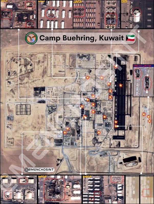
The most credible assessments suggest that the primary objective was not maneuvering forces themselves, but the logistical backbone that enables sustained military operations. Impact points are concentrated within the camp's central compound, where support facilities, utility infrastructure, warehouses, and logistics nodes are densely clustered.
The strike pattern appears precise rather than random, indicating the selective targeting of high-value infrastructure clusters essential to the camp's operational mission.
Among the most significant damage visible in satellite imagery is the heavily burned electrical substation, showing extensive scorching, blackened equipment, destroyed transformer banks, and substantial debris. Damage to electrical infrastructure can have cascading operational effects, disrupting power supply across large sections of the installation and degrading multiple support functions simultaneously.
Containerized housing units and modular troop accommodations also display localized burn damage, with several structures destroyed. Nearby rectangular buildings consistent with warehouses, maintenance facilities, and logistics storage complexes exhibit roof collapses, extensive burn marks, and structural damage.
The targeting philosophy appears clear: rather than attempting to destroy the entire base or inflict maximum personnel casualties, the strikes seem intended to degrade logistics throughput, maintenance capacity, electrical support systems, supply handling, troop accommodation, and staging operations.
For a logistics hub such as Camp Buehring, impairing these functions can significantly reduce operational effectiveness even if much of the physical infrastructure remains standing.
Overall, satellite imagery provides strong indications that critical electrical infrastructure sustained severe damage, warehouse and storage complexes suffered extensive fire and structural impacts, and sections of the containerized housing area experienced localized destruction.
The evidence points to a sustained effort to reduce Camp Buehring's operational capacity by targeting the infrastructure that underpins its logistical mission.
Ali Al Salem Air Base: A strategic air hub paralyzed
Ali Al Salem Air Base, located approximately 60 kilometers west of Kuwait City near the Iraqi border, is one of the most strategically important American-operated air facilities in Kuwait.
It serves as a major logistics, surveillance, aerial refueling, and expeditionary aviation hub supporting US Central Command (CENTCOM) operations across the Persian Gulf and wider West Asian region.
Years of satellite imagery reveal a classic desert airbase centered on a long primary runway capable of accommodating heavy aircraft, including C-17 Globemaster III strategic airlifters, KC-135 aerial refueling tankers, and a range of intelligence, surveillance, and reconnaissance (ISR) platforms. An extensive network of taxiways connects the runway to multiple hardened and semi-hardened aircraft parking aprons, maintenance areas, and support facilities.
One of the installation's defining characteristics is the dispersed arrangement of its aircraft parking areas, reflecting a long-standing operational assumption that regional air superiority, layered air defenses, and missile defense systems would substantially reduce vulnerability to enemy attack.
The Iranian missile strikes on Ali Al Salem, beginning on February 28 and followed by renewed attacks on March 1 and subsequent days, demonstrated the limitations of that.
Satellite imagery analyzed by open-source intelligence communities indicates massive damage to hangars, support buildings, and critical sections of the base's operational infrastructure. Assessments also suggest impacts affecting aircraft shelters, radar installations, communications facilities, and other assets essential to sustained air operations at the base.
Rather than concentrating on a single section of the base, the impact points appear distributed across much of the installation, with visible clusters surrounding aircraft support areas, logistics and administrative compounds, communications facilities, utility infrastructure, and airfield support complexes.
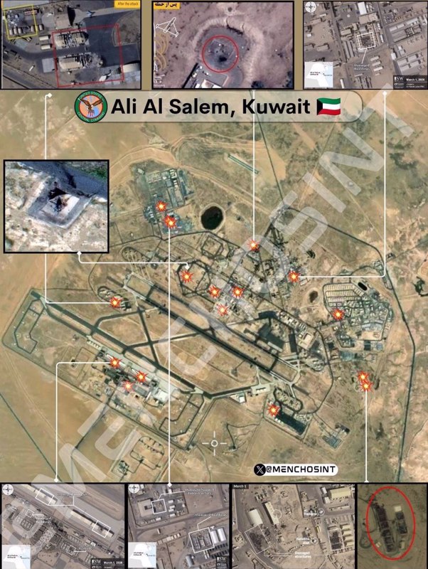
Notably, the runway itself does not appear to have been the principal focus of the strikes. This is consistent with contemporary military targeting doctrine, which often prioritizes command-and-control centers, fuel distribution systems, communications networks, radar installations, electrical infrastructure, and maintenance facilities over runway cratering.
While damaged runways can often be repaired relatively quickly, disabling the systems that sustain air operations can impose far more enduring operational constraints.
One satellite image appears to show significant damage to a power distribution or electrical substation area, including what resembles transformer banks, switching equipment, and electrical infrastructure exhibiting extensive scorching and structural disruption.
Damage to such facilities can affect multiple operational systems simultaneously, reducing the base's overall effectiveness well beyond the immediate impact zone.
Another image shows a circular impact site with a prominent central crater, surrounding ejecta, and apparent destruction of a small installation consistent with a radar position, communications node, or sensor emplacement.
Other imagery depicts a radome, satellite communications equipment, and damaged support structures. Such communications infrastructure is often more operationally significant than runway damage because it directly affects command networks, intelligence dissemination, air operations coordination, and battlefield communications.
The concentration of damage within support compounds rather than aircraft parking areas further suggests that the strikes were designed to degrade the infrastructure enabling sustained air operations rather than maximize aircraft destruction.
The strike pattern is consistent with a strategy aimed at reducing operational capacity by targeting the logistical, communications, electrical, and command infrastructure upon which the base depends. Such an approach can produce longer-lasting operational disruption than runway attacks alone, while significantly complicating repair and recovery efforts.
Camp Arifjan: Forward logistics node
While detailed satellite imagery of Camp Arifjan is less extensive than that available for several other targeted installations, the base's strategic importance and its inclusion in Iran's retaliatory campaign make it a critical component of the broader operational picture.
Camp Arifjan serves as the principal forward logistics hub for US ground forces in Kuwait, providing the supply-chain infrastructure that enables the deployment, sustainment, and support of American land operations throughout the US Central Command (CENTCOM) theater. Its strategic significance lies not in combat aircraft or naval assets, but in its role as the logistical backbone of US expeditionary ground forces.
Modern military operations depend on uninterrupted logistical throughput. Fuel depots, vehicle maintenance facilities, communications networks, electrical infrastructure, ammunition storage, and transportation nodes form an integrated support system that enables combat formations to operate over extended periods.
Disrupting this infrastructure can produce operational effects far exceeding the immediate physical damage. Even localized strikes against fuel storage, maintenance complexes, communications facilities, electrical substations, or transportation hubs can generate cascading disruptions throughout the supply chain, reducing force readiness, delaying equipment repairs, constraining mobility, and impairing the deployment and sustainment of frontline units.
Within this operational framework, Iranian retaliatory strikes against Camp Arifjan appear consistent with a broader strategy aimed not at destroying combat formations directly, but at degrading the logistical architecture that underpins American ground operations across the Persian Gulf.
By targeting the infrastructure that sustains military power rather than the forces themselves, such strikes can impose lasting operational constraints that extend well beyond the immediate impact area.
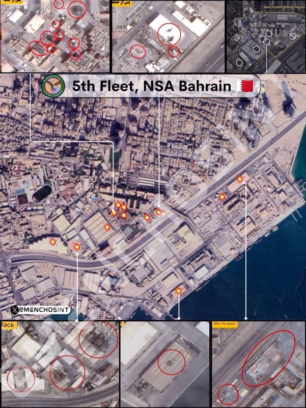
Naval Support Activity Bahrain: Fifth Fleet headquarters under siege
Naval Support Activity Bahrain, located on Bahrain's northeastern coast, serves as the headquarters of the US Navy's Fifth Fleet and is among the most strategically significant American naval installations in West Asia.
The facility functions as the command center for naval operations across the Persian Gulf, the Gulf of Oman, the Arabian Sea, and parts of the Indian Ocean.
Satellite imagery reveals a sprawling complex comprising port infrastructure, command-and-control buildings, communications systems, maintenance facilities, logistics hubs, piers, and a range of operational support installations. Commercial imagery routinely captures large naval vessels, patrol craft, and auxiliary ships moored at the base.
Its greatest strategic value, however, lies not in the ships it hosts but in its role as the nerve center coordinating American naval operations throughout the region.
During Operation True Promise 4, the Fifth Fleet headquarters came under direct attack, with multiple Iranian ballistic missiles and kamikaze drones striking the installation. Video footage captured several impacts within the base complex, including strikes on a high-rise building reportedly housing American personnel.
The Islamic Revolution Guards Corps (IRGC) announced that a Fifth Fleet service center had been precisely targeted. Follow-on strikes on March 1 hit an American naval command and backup command facility with at least two ballistic missiles, indicating a sustained campaign against the installation's command infrastructure.
Available satellite imagery indicates that the strikes were not concentrated along the waterfront or directed primarily at naval vessels. Instead, impact locations are distributed across interior compounds, administrative sectors, building clusters, and support facilities, suggesting a deliberate focus on the land-based infrastructure that enables command, coordination, and sustainment of naval operations.
The targeting philosophy centered on command-support infrastructure, communications nodes, operations centers, data-processing facilities, intelligence systems, and network infrastructure rather than ships or port facilities alone. Multiple impact locations, destroyed buildings, burn scars, debris fields, collapsed roof sections, and extensive fire damage are visible across several compounds.
The strike pattern suggests repeated attacks against selected facilities rather than isolated impacts. In several areas, multiple strikes appear concentrated within the same compound, consistent with efforts to ensure the destruction or disablement of high-value targets.
Other imagery shows clusters of impacts around central administrative sectors, reinforcing the assessment that command-and-control infrastructure was a principal objective.
One satellite image also indicates damage to a structure located on a pier or waterfront support facility. Although relatively modest in size, such infrastructure can play a disproportionately important operational role by supporting port logistics, communications, utilities, and naval sustainment functions. Damage to these facilities can therefore affect operational capacity well beyond the immediate impact area.
Notably, the overall strike pattern is consistent with a plan designed to degrade the Fifth Fleet's command, communications, logistics, and support infrastructure. Such an approach aligns with a broader strategy of disrupting operational effectiveness by targeting the systems that enable American maritime power projection rather than the ships alone.
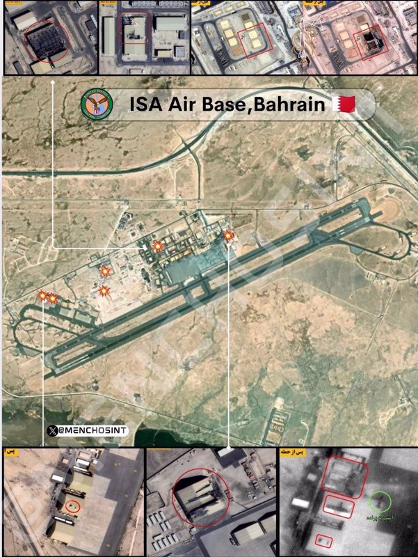
Isa Air Base: Bahrain's principal aviation installation neutralized
Isa Air Base, located in southern Bahrain, serves as the kingdom's principal military aviation installation and has long functioned as a critical regional hub supporting Bahraini operations while hosting American coalition aircraft. Satellite imagery reveals a classic modern air-base configuration, comprising long runways, taxiways, hardened aircraft parking areas, maintenance facilities, and extensive support infrastructure.
Though somewhat smaller than Al Dhafra Air Base, Isa remains strategically vital due to its geographic position, providing essential depth for coalition aviation operations across the region. Its location within Bahrain places it in close proximity to key maritime chokepoints and shipping routes that connect the Persian Gulf with the broader Indian Ocean region.
Over the years, commercial satellite imagery has documented continual modernization efforts, including upgrades to parking aprons, maintenance areas, and air-defense support infrastructure. Analysts frequently monitor the site as it serves as a reliable indicator of regional military activity, with aircraft dispersal patterns, temporary deployments, and construction projects often visible from space.
During the recent war of aggression, regional reporting and broader assessments of attacks on Persian Gulf military infrastructure indicate that Bahraini military facilities were among those exposed to missile and drone threats.
Satellite imagery shows Isa Air Base to be a much more compact installation than Al Dhafra or Ali Al Salem, and the strikes appear concentrated on a relatively small number of facilities rather than spread across the entire base.
The impact symbols are clustered almost entirely around the northern operational zone, with strikes concentrated in hangar areas, maintenance compounds, support facilities, and technical infrastructure, a much tighter pattern than what was observed at other installations, suggesting a more focused and deliberate target set.
One satellite image offers a stark before-and-after comparison: an intact roof on a rectangular industrial structure in the earlier image, followed by severe burn damage, extensive roof collapse, and a dark debris field in the later capture. The destruction appears substantial, suggesting either direct impact, internal fire, or secondary explosions.
Another image appears to depict a small, enclosed compound housing several utility or technical structures, with before-and-after imagery revealing a large central crater and widespread destruction within the compound, possibly indicating damage to utility infrastructure, power systems, communications equipment, or technical support facilities.
Additional satellite imagery shows aircraft support infrastructure featuring large maintenance buildings, adjacent support areas, and equipment storage, with the highlighted structure exhibiting apparent roof damage, fire effects, and structural disruption.
The targeting of maintenance infrastructure is particularly significant because, for an air base, such facilities are often more difficult and time-consuming to replace than runway pavement. While runways can be rapidly repaired using specialized equipment and prefabricated materials, maintenance infrastructure, with its specialized equipment, technical systems, and trained personnel requirements, represents a far more challenging and costly restoration effort, underscoring the strategic intent behind the strikes.

Al Dhafra Air Base: Intelligence hub degraded
Al Dhafra Air Base, located south of Abu Dhabi in the United Arab Emirates, stands as one of the most sophisticated military aviation facilities in the Persian Gulf. It serves not only the UAE Air Force but also hosts US and French military operations, functioning as a critical hub for intelligence, surveillance, reconnaissance, aerial refueling, and long-range strike support.
Satellite imagery reveals a highly developed airfield featuring dual long runways, extensive apron space, maintenance complexes, aircraft shelters, and command infrastructure.
Historically, satellite analysts have paid particular attention to Al Dhafra because of its association with high-value airborne intelligence platforms, including surveillance aircraft, remotely piloted systems, and airborne early warning assets.
Earlier imagery studies documented specialized UAV infrastructure, including satellite communication links and control stations – evidence of the base's role as a cornerstone of coalition intelligence-gathering in the region.
During Operation True Promise 4, Iranian missiles and kamikaze drones descended upon Al Dhafra with devastating precision, destroying the American air warfare center, satellite communication center, early warning radars, and fire control radars.
The retaliatory attack effectively decapitated the base's command and control capabilities, striking at the very heart of its operational function. Satellite imagery shows localized damage concentrated around hangars and support structures rather than catastrophic destruction of the entire base, a pattern consistent with targeted strikes designed to disable rather than demolish.
Multiple analyses note burn marks, damaged roofs, and impacts affecting aircraft shelter areas, with several reports specifically highlighting damage around structures associated with UAE airborne surveillance assets.
The strike locations are widely distributed across aviation support areas, infrastructure compounds, administrative sectors, utility zones, and communications-related facilities, suggesting a deliberate attempt to affect multiple functions simultaneously rather than concentrating on one specific target set. This distributed approach indicates sophisticated targeting intelligence and a clear understanding of the base's operational architecture.
The absence of runway-focused damage is particularly significant. Modern military planners often prefer attacking fuel systems, maintenance facilities, command infrastructure, and communications nodes because these require much longer repair times than runways, which can be quickly restored using specialized equipment.
By targeting these harder-to-replace systems, the strikes ensured that the base's operational capacity would remain degraded for an extended period.
Satellite imagery provides stark visual evidence of the destruction. One image shows building destruction with severe roof collapse, interior exposure, burn damage, and rubble fields, with one structure appearing almost completely destroyed.
Another satellite image depicts a long rectangular building with extensive internal damage, its roof partially removed or collapsed, with darkened internal sections suggesting fire damage, structural failure, and possible secondary explosions.
The central support district contains several strike markers clustered around maintenance facilities, utility structures, and technical support buildings.
Additional satellite imagery shows structures resembling technical compounds, utility buildings, or communications facilities with apparent damage to two enclosed structures. Other imagery reveals extensive structural damage, multiple destroyed buildings, large debris fields, and significant burn scars, representing one of the largest contiguous damaged areas visible in the satellite photographs.
Notably, the imagery does not show clear evidence of destroyed aircraft or burned aircraft, indicating that the focus was deliberately placed on buildings, infrastructure, and support systems rather than aircraft themselves. This targeting strategy suggests an intent to cripple the base's ability to function as a command and support hub, rather than merely reducing its aircraft inventory, a far more strategic and lasting form of degradation.
Long-Range radar sites: Blinding the American air defense network
Perhaps the most strategically significant achievement of Operation True Promise 4 was the systematic targeting of long-range radar installations across the Persian Gulf region.
These facilities form the sensor layer that enables interception, tracking, and command coordination for integrated air-defense systems. Unlike air bases or naval headquarters, radar sites typically occupy relatively small footprints, but their operational importance often exceeds their physical size.
A single destroyed antenna can render an entire installation ineffective. Satellite imagery and battlefield reports confirm that Iranian retaliatory strikes degraded or destroyed multiple key radar systems across the region, fundamentally altering the strategic balance.
The crown jewel: Al-Udeid's billion-dollar blind spot
The most significant achievement was the severe destruction of the AN/FPS-132 Upgraded Early Warning Radar at Al-Udeid Air Base in Qatar. This fixed UHF phased-array radar, designed to detect and continuously track ballistic missiles at extremely long ranges, represented the most critical component of the US early warning architecture in West Asia.
Valued at approximately $1.1 billion, it was the cornerstone of American missile defense in the region. Its obliteration rendered the entire American air defense network effectively blind, forcing surviving batteries to operate with degraded situational awareness and dramatically reducing their effectiveness against subsequent Iranian strikes.
Satellite imagery suggests damage to the radar structure itself, with before-and-after comparisons showing visible alteration near the radar face or supporting structure.
While the installation remains visibly standing from a bird's eye view, with blackened damage to the northeast facade, leaked photos from the scene, published in major global media outlets, reveal that the damage from Shahed drones is significantly more extensive.
These images show that the drones struck the phased-array antenna, the ground floor of the building, and the tower itself, where the ravages of a raging fire remain clearly visible. The damage undoubtedly degraded its operational capability in an irreversible manner.
Decapitating command and control
At Al Dhafra Air Base, early warning radars and fire control radars were destroyed alongside command and control centers, equally significant losses, as these facilities served as the nerve centers through which American intelligence operations across the Persian Gulf were coordinated.
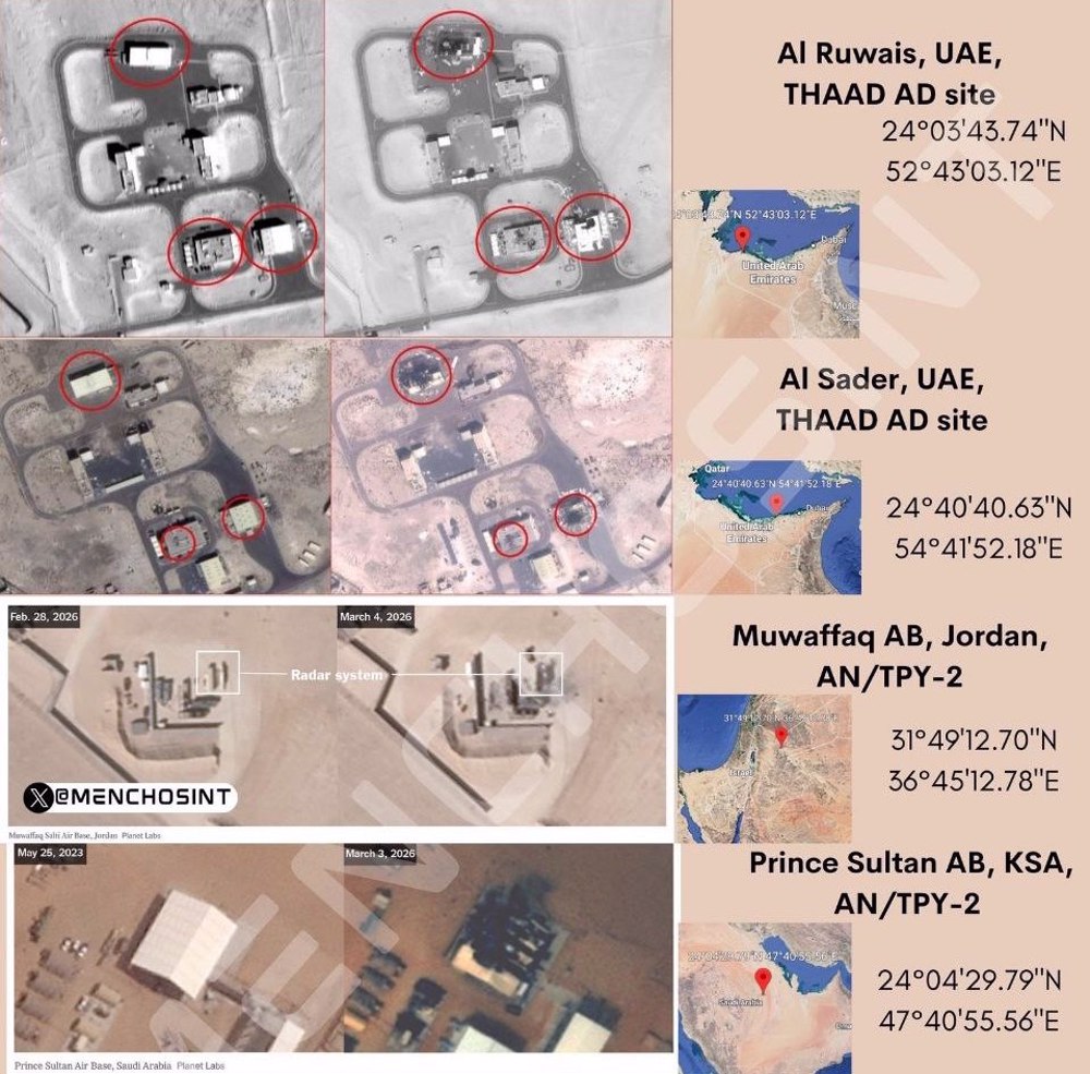
At the US al-Azraq base in Jordan, Iranian long-range missiles targeted and destroyed four major targets, including hangars housing F-35 fighter jets and a command-and-control center. At Prince Sultan Air Base near Al-Kharj in Saudi Arabia, although Saudi forces claimed to have intercepted three missiles, the installation still suffered significant damage, underscoring the penetrating power of the strikes.
A regional radar network in ruins
Multiple other radar sites across the Persian Gulf were targeted in a coordinated campaign that demonstrated remarkable intelligence and precision. At Al Ruwais in the UAE, a THAAD site shows damage concentrated on three structures, appearing centered on equipment shelters, support facilities, and technical buildings.
At Al Sader in the UAE, another THAAD site displays a similar pattern, with darkened surfaces, roof damage, and burn scars concentrated on a few specific buildings.
At Muwaffaq Air Base in Jordan, the imagery appears to focus directly on a radar installation, with the before-and-after sequence suggesting that the highlighted feature appears altered or partially absent.
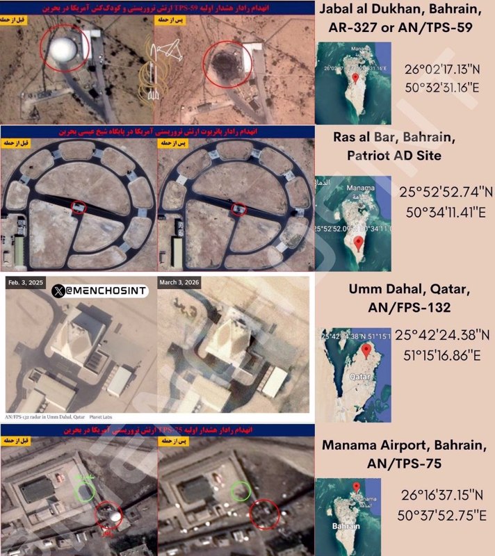
Bahrain: A case study in radar destruction
At Jabal al Dukhan in Bahrain, the before-and-after sequence provides perhaps the most visually persuasive evidence of radar destruction.
The earlier image shows what appears to be a radome, the spherical protective cover often placed over radar antennas, intact and operational. The later image reveals that the sphere appears absent, replaced by a dark damaged area. If this interpretation is correct, a radar antenna cannot continue operating once its radome and underlying sensor are destroyed. This single strike likely neutralized a critical node in the regional air-defense network.
At Ras al Bar in Bahrain, a Patriot site shows disturbance around the central equipment area, though damage signatures appear subtle.
At Manama Airport in Bahrain, an AN/TPS-75 radar installation exhibits disturbance, possible structural damage, and debris signatures, further evidence of the campaign's breadth.
A suppression-of-air-defense strategy
The targeting pattern is consistent with a sophisticated suppression-of-air-defense strategy. A missile-defense battery without functioning sensors becomes dramatically less effective, a vulnerability that Iranian planners clearly understood and exploited.
The chosen sites form a geographic arc stretching across the UAE, Bahrain, Qatar, Jordan, and Saudi Arabia, collectively contributing to monitoring airspace across much of the Persian Gulf region. By striking this network in a coordinated fashion, Iran effectively created corridors of vulnerability through which subsequent strikes could operate with reduced risk of interception.
The target selection consistently focuses on radar, sensor, and missile-defense infrastructure rather than on runways, barracks, or logistics facilities. This is not the pattern of a campaign seeking to destroy bases for their own sake. It is the signature of a strategic operation designed to degrade the regional sensor network that supports air and missile defense across the Persian Gulf.
The pattern suggests an operation less about destruction and more about strategic blinding, a decisive shift in the balance of power that allowed Iran to project force with unprecedented freedom of action.
Military-technological triumph of Operation True Promise 4
The first days of the war demonstrated conclusively that Iranian military technology has reached a level of sophistication American strategists never anticipated.
Iranian missiles consistently penetrated American air defenses, striking their targets with precision that rivals or exceeds that of US weapons. Iranian drones swarmed American bases in numbers that defensive systems simply cannot engage, a testament to the evolution of asymmetric warfare and Iran's mastery of it.
The destruction of the AN/FPS-132 radar represents perhaps the most significant single technological achievement of the campaign: a billion-dollar system, specifically designed to detect and track missiles like those Iran fired at it, proved utterly incapable of preventing its own destruction.
This was not merely a tactical failure but a fundamental challenge to the very premise of American air-defense doctrine. The system that was supposed to guarantee early warning and enable interception was neutralized by the very weapons it was built to counter.
The implications were staggering: if America's most advanced early-warning radar cannot survive an Iranian strike, what can?
The performance of Iranian anti-ship missiles against American naval assets further demonstrated the comprehensive nature of Iran's capabilities. No domain – whether air, land, or sea – remained immune. The Fifth Fleet headquarters in Bahrain, the carrier strike groups in the Persian Gulf, and the air bases scattered across the region all proved vulnerable.
This was the arrival of a new strategic reality, one in which the United States can no longer assume dominance in any battlespace.
Beyond technology, the sustained nature of the Iranian campaign revealed logistical and industrial capacities that the US clearly did not anticipate. Iran fired hundreds of missiles and drones while maintaining the ability to continue such strikes indefinitely, a feat that suggests a production capacity Western intelligence had catastrophically underestimated.
American forces, by contrast, expended enormous quantities of interceptors attempting to defend against Iranian attacks, depleting stocks that will take years to replenish. The economics of this war were as devastating as its tactics: a missile that costs Iran a few hundred thousand dollars is met by an interceptor that costs America several million.
This is a war of attrition that the United States can never win. Every engagement drains American resources while preserving Iranian capabilities. The technological edge upon which American military dominance has rested for decades was revealed as a myth. The industrial capacity that was supposed to guarantee American superiority was exposed as insufficient.
The message from Tehran to Washington could not be clearer: the era of American dominance in West Asia has ended. Any future aggression against the Islamic Republic will be met with responses far more devastating than anything yet seen.
Press TV’s website can also be accessed at the following alternate addresses:

IRGC warns of stronger response to any US-Israeli ceasefire violations
US carrot-and-stick gambit backfires as Iran asserts Hormuz sovereignty, asymmetric deterrence

Iran built more sophisticated weapons during latest US-Israeli onslaught: Army spox